FIELD NOTES BLOG
Climate in the News: Coastal Sea Levels Are Higher Than Previously Thought
A new study published in the journal Nature, titled Sea Level Much Higher Than Assumed in Most Coastal Hazard Assessments is making headlines around the world. In case you missed it, researchers have recently found that coastal sea levels are, on average, 8 -12 inches higher than many maps and models have previously suggested. This discovery means that many coastal areas are at an even greater risk from rising sea levels than we previously believed.
So, what went wrong? And how did researchers discover this gap? Let's break it down.
The discrepancy between the previously estimated sea levels versus the Earth's actual sea levels comes from an error in the modeling methods used to predict them. Measuring global sea level is much more complicated than you may initially think, and it’s challenging to accurately measure because it requires averaging a constantly moving, non-spherical ocean surface, which is only further complicated by factors such as shifting landmasses, inconsistent gravitational pulls, and regional differences such as melting ice sheets and ocean currents. For all of these reasons, it’s impossible to use a simple ruler method to measure our oceans' depth.
To combat this, researchers commonly rely on a method called geoid modeling to measure Earth's coastal sea levels. A ‘geoid’ is an irregular shaped model of the Earth that is based on where gravitational forces on Earth are stronger and weaker. Using a geoid model of the Earth then allows scientists to estimate average sea level based on Earth’s gravitational field. This type of modeling is used to measure sea level because it provides a gravity-based, uniform, "zero elevation" surface that represents where water would settle without tides or currents that accounts for the Earth's irregular shape, uneven mass distribution, and variable gravity– all factors that make this calculation so challenging.
Though geoid modeling has been widely used and accepted in the scientific community, it hasn’t captured all contributing factors influencing sea level like we once believed, failing to accurately account for regional ocean currents, winds, sea water temperature, or salinity. As a result, time-average sea-surface height can deviate up to several meters from the predicted sea level of a geoid model. Without accurately accounting for these variations, scientists have unknowingly been over and under estimating the sea level in certain areas of the world.
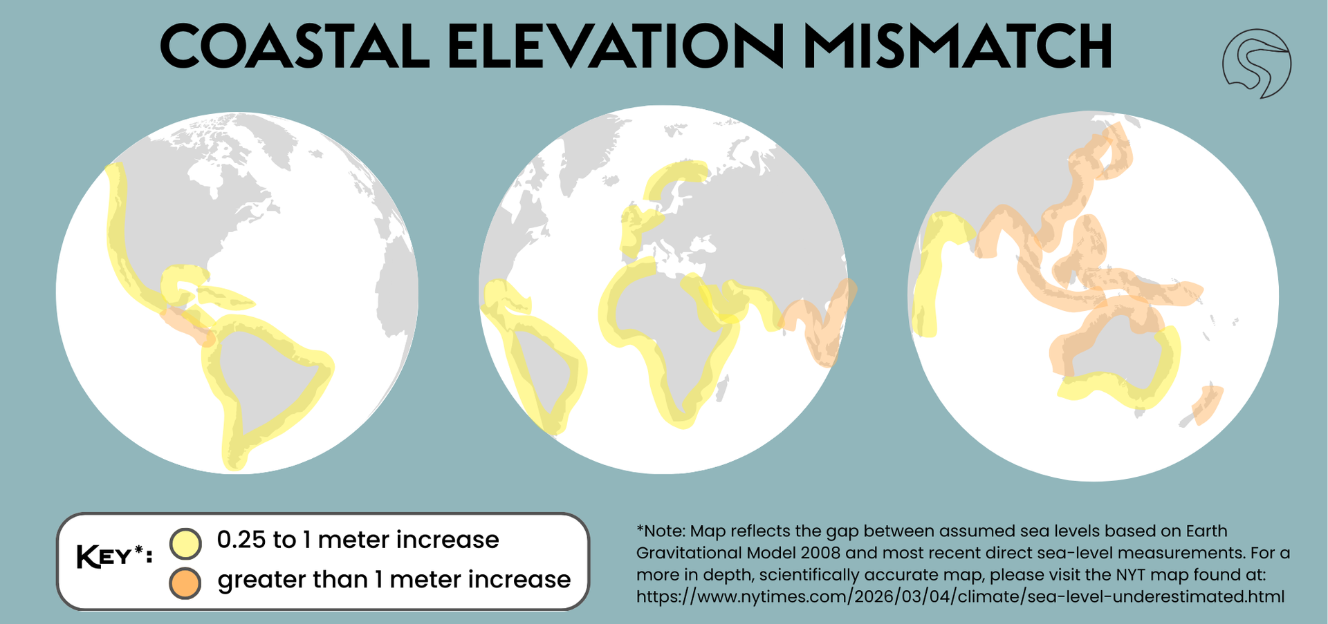
The study found that geoid modeling works relatively well at measuring the coastal sea level in the Northern Hemisphere (read: The United States, Canada, and Europe), where sea level changes are more predictable. However, the model falls short in other regions of the world, particularly in the Southern Hemisphere where ocean dynamics are more complex, particularly in South East Asia and Oceania. In these areas, sea levels are actually several meters higher than previously estimated. As you can imagine, this finding has serious implications for hazard assessments and coastal vulnerability predictions that we use to estimate how sea level rise may affect nations around the world. Currently, 90% of hazard assessments, which are assessments that help policymakers anticipate the impacts of sea level rise, are based on geoid model data rather than actual sea-level measurements. As a result, these assessments have underestimated the risks to coastal populations, and failed to capture the full extent of the threat of sea level rise. This study estimates that if sea levels were to rise by one meter, using measured sea-level data rather than geoid-based assumptions,
this would place 31–37% more land and 48–68% more people below sea level. In total, that could mean 77–132 million more people living in areas vulnerable to sea level change.
It’s important to note that although the findings of this study are shocking and change our understanding of coastal vulnerability predictions, they do not fundamentally change what we know about the risk of rising sea levels. Sea levels are continuing to rise globally, and coastal communities around the world remain at risk. This has not changed. What this study does change, rather, is our starting point when making coastal vulnerability prediction and risk assessments, as the threat of sea level rise is actually already closer than we thought in many regions of the world.
Sources
The New York Times: Sea Levels Are Already Higher Than Many Scientists Think, New Study Shows
Nature: Sea level much higher than assumed in most coastal hazard assessments

RECENT ARTICLES